Metes and Bounds Survey

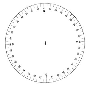
The metes and bounds survey system was developed in England,before the European discovery of the Americas. According to Black’s Law Dictionary, metes means to measure and bounds means boundary. As such, a metes and bounds survey is one that measures the boundary lines of a particular area of land, which can be of any size or shape. A metes and bounds survey must begin at a particular point. Standing at the given point of beginning, the surveyor must determine true north and then determine the direction of the first line of the survey. The surveyor typically uses a quadrant notation compass, like the one depicted above, to determine direction. An imaginary line, called a meridian, runs from north to south on the compass. A similar line, called the baseline, runs from east to west on the compass. The meridian and baseline intersect in the middle of the compass. Accordingly, a quadrant compass is divided into four quadrants with north at the top of the compass. Proceeding clockwise, the first quadrant begins at zero degrees north and ends at ninety degrees due east. The second quadrant begins at ninety degrees east and ends due south at zero degrees. The third quadrant begins at zero degrees south and ends due west at 90 degrees. Finally, the fourth quadrant begins at 90 degrees west and ends at zero degrees north. The middle of the compass is the beginning point of a line. A line heading in a northeast direction would begin in the middle of the compass and simply extend toward the mark of 45 degrees in the northeast quadrant of the compass.
The first directional description of a metes and bounds survey indicates whether the line extends north or south of the baseline. The second directional description indicates whether the line extends east or west of the meridian. For example, in the line described as S 59°09 minutes 59 seconds W, the “S” indicates that the line will extend south of the baseline. The second directional description, indicated by the “W” at the end of the description, indicates that the line will proceed west of the meridian. As such, the description above indicates that the line will head in a southwest direction from the point of beginning at the center of the compass and lie somewhere within the southwest quadrant of the compass. Where within the quadrant it will lie is determined by the degrees, minutes, and seconds as stated in the description of the line.
Each degree is divided into 60 minutes, and each minute is divided into 60 seconds. As such, one-half of a degree equals 30 minutes, and one-half of a minute equals 30 seconds. The line description above of S 59°09 minutes 59 seconds W states that the line is situated in the southwest quadrant of the compass and that is extends precisely to the mark on the compass of 59 degrees, 9 minutes, and 59 seconds, or just slightly more than 59 degrees. Lastly, the description of a line will end with the length of the line. Thus, a boundary line that is 33.21 feet will be expressed as S 59°09 minutes 59 seconds W, 33.21 ft. The surveyor will then walk 33.21 feet in the southwest direction as indicated and start the process over, placing the center of the compass over the point at the end of the 33.21 feet, determine true north and determine the direction and distance of the next line. This process is repeated until the boundary is closed at the point at which the survey began.
Chains and Links
Early surveys used the Gunter chain to measure distance, expressed as chains and links. One chain equaled 22 yards, and the chain contained 100 links, each link measuring 7.92 inches in length.) The following survey used the public land survey system and metes and bounds measured by a Gunter chain to describe a 3.2 acre parcel of land situated in Iron County, Missouri.
“Beginning at the northeast corner of lot 4 of the northeast quarter of section 2, township 33 north, range 4 east; thence west 9.50 chains to the east marginal line of Lake Killarney; thence in a southeasterly direction along said east marginal line of said lake as follows: South 41 degrees east 2.40 (2.04) chains, south 36 degrees east 1.90 chains; south 41 degrees east 93 links to an intersection with a barbed wire fence; thence east 2.04 chains to a red oak tree 14 inches in diameter, the terminus of said barbed wire fence; thence east 4.46 chains to the line dividing sections 1 and 2, township 33 north, range 4 east; thence north along said line 4.00 chains to point of beginning, containing 3.20 acres, all in the northeast corner of lot 4 of the northeast quarter of section 2, township 33 north, range 4 east.”
This article is for general informational purposes only, and it is not intended as legal advice.
Sewell Law provides legal services in the areas of litigation, real estate, and business, including the formation of self-directed IRA LLCs and conventional LLCs. Please contact Michael Sewell at (314) 942-3232 or at michael@sewelllaw.net to discuss your legal matters.
The choice of a lawyer is an important decision and should not be based solely upon advertisements.
© 2020 Sewell Law, LC


