Public Land Survey System

The First Survey
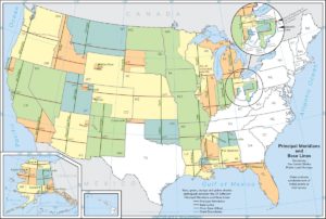
The United States wasted no time implementing the public land survey system. In 1785, Congress appointed Thomas Hutchins as the chief geographer of the United States. In that same year, Hutchins’ team began the first survey under this new system at the intersection of the Ohio river with the western boundary line of the state of Ohio, depicted by the red dot on Map 1 below. His team surveyed seven ranges heading due west for 42 miles. The public land survey system has since been used by the federal government to survey the entirety of thirty states, as shown on Map 1.
Townships and Ranges
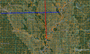
Arkansas, Missouri, Iowa, and North Dakota, part of western Minnesota, and the eastern half of South Dakota are all surveyed from the initial point of the Fifth Principal Meridian (5th PM). The 5th PM is shown as the red line on Map 2 below. It was set by an act of the U.S. Congress as a line of longitude running north-south through the mouth of the Arkansas river. The baseline of the 5th PM is the blue line shown on Map 2. It was set by the same act of Congress as a line of latitude running east-west through the mouth of the St. Francis river. The intersection of these two lines form the initial point of the 5th PM. (The 5th PM and its baseline are also shown on Map 1 above.) Each orange square on Map 2 is a township, and each column of townships is a range six miles wide. Each range is indicated as lying either east or west of the principal meridian, and the range numbers increase as they move away from the principal meridian.
For example, the first column of townships to the right of the 5th PM, shown on Map 2, is range 1 east. The column of townships to the right of range 1 east is range 2 east, the column to the right of that is range 3 east, and so on. The first column of townships to the left of the 5th PM is range 1 west. The column of townships to the left of range 1 west is range 2 west, the column to the left of that is range 3 west, and so on. Each township is designated as lying north or south of the baseline. Like the number of a range, the township numbers increase as they move away from the baseline. As such, the township situated at the northeast corner of the initial point is township 1 north (T1N), range 1 east (R1E). The township above that is T2N, R1E. The townships simply increase in number as they progress north. The same occurs south of the baseline. The township situated at the southeast corner of the initial point is T1S, R1E. The township below that is T2S, R1E. Marianna, AR is located on Map 2 in T2N, R3W. Stuttgart, AR, southwest of the initial point, is located in T2S, R5W. Finally, Jacksonville, AR, located northwest of the initial point, is situated in T3N, R10W.
Sections
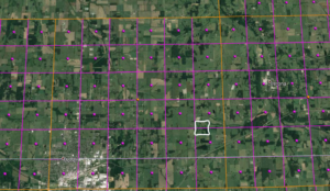
As stated, each township is divided into 36 sections, each one mile long and one mile wide. Each section contains 640 acres. The orange square shown on Map 3 below is township 26 N in range 27 W, located in southwest Missouri.
Thus, this township is 26 townships north of the baseline of the 5th PM, and it is in the 27th range west of the 5th PM. Each purple square shown on Map 3 is a section of a township. Section numbering begins in the northeast corner of a township and moves west laterally. As such, the section in the northeast corner of T26N, shown on Map 3, is section 1, the section to the left of that is section 2, and the section in the northwest corner of T26N is section 6. The section below section 6 is section 7, the section to the right of that is section 8 and the last section of that row is section 12. The section numbering proceeds accordingly, ending with section 36 in the southeast corner of the township. Sections are further divided into halves and quarters and quarters of quarters. The area outlined in white on Map 3 is located partially in section 24 and partially in section 25. (Section 25 is directly below section 24.) More specifically, the area outline n white on Map 3 is situated in the south half of the southwest quarter of section 24 and in the north half of the northwest quarter of section 25. The survey of the white area reads as follows:
The South Half (S½) of the Southwest Quarter (SW¼) of Section Twenty-four (24), and all the North Half (N½) of the Northwest Quarter of Section Twenty-Five (25), all in Township Twenty-six (26), Range Twenty-seven (27), Lawrence County, Missouri.
The white area on Map 3 is 160 acres, as a quarter of a section is 160 acres (640 acres/4 = 160 acres), and half of that is 80 acres. Sections can also be further divided into lots, which tend to be irregular in size and shape.
Authored by Michael John Sewell, founder of Sewell Law, where he practices in the areas of real estate, business, and civil litigation. www.sewelllaw.net; michael@sewelllaw.net; (314) 942-3232.
The choice of a lawyer is an important decision and should not be based solely upon advertisements.
© 2019 Michael John Sewell and Sewell Law, LC


